区域降水自动检测系统

- 产品描述
- 技术特点
- 规格参数
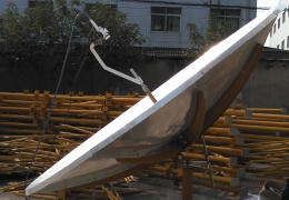
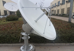
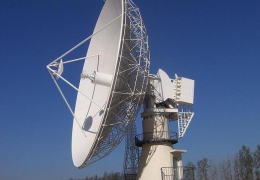
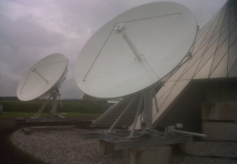
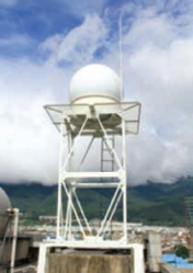
区域降水自动监测系统分为PRS-11和PRS-11/M两类,是一个具有高时空分辨率和连续空间的降水监测系统。该系统具有国际先进技术,可广泛用于降雨监测、降雨强度监测、中小河道洪水、山地灾害、城市内涝、公路、铁路、航空和电力线路、区域水质,水资源等方面。
PFS-11系统的功能与特征
高时间空间分辨率:雨量测量站每5分钟输出10秒的粒子大小光谱和速度频谱。现场监测站输出90×90㎡的区域降水量场
空间分辨率,优于目前500*500国际水平。
无缝区降水:基于高时空分辨率,能够在36km半径范围内实现连续空间覆盖(月4000k㎡),提高降水量的代表性。
最优仰角扫描:根据周围建筑物和地形,可以将降水雷达天线设置为最优可变扫描高程,以减少城市建筑物和复杂山地地形的影响。
垂直扫描:雷达执行垂直扫描捕获的信息和滴量计测量的频谱数据将发送到终端系统的衰减模型,补偿x波段雷达衰减的不足。
无人操作:大量的控制和分析应用软件如自动报警和自动监测,为系统自动连续运行和自动降水场测量提供了保障。
高性价比:实时衰减校正和动态数学物理模型提高了系统区域降水的定量测量能力。科学设计使系统具有可靠性高、施工、运行和维护成本低等优点。
广泛应用:该系统适用于水利、交通、农业、军事、电力、能源、气象、海洋等科研部门进行抢险救灾和公安服务。
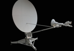
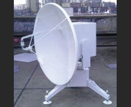
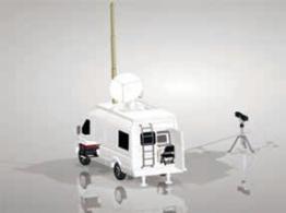
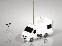
区域降水自动监测系统分为PRS-11和PRS-11/M两类,是一个具有高时空分辨率和连续空间的降水监测系统。该系统具有国际先进技术,可广泛用于降雨监测、降雨强度监测、中小河道洪水、山地灾害、城市内涝、公路、铁路、航空和电力线路、区域水质,水资源等方面。
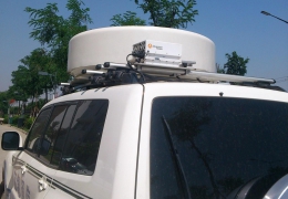
PRS11/M 系统的功能和特性
u 良好的流动性和跨国能力。
u 快速简易的安装和拆卸。
u 自动水平和对北
u 降水监测雷达采用相参脉冲多普勒系统,具有高性价比和低寿命周期成本。
u 该系统的激光滴量计可以提供多个参数。
u 能够提供实时降水累积和检测区域小时降水量,每5分钟更新一小时、三小时和六小时的区域降水。
u 能够提供来自降水监测雷达子系统的监测数据,例如,原始产品的图像分布信息,如天气回波强度、平均径向速度和速度谱宽度等。
u 能够提供滴量计电子系统的监测数据和降水粒子直径、粒子速度、雷达反射率和降雨强度的实时数据。
u 能够通过以太网快速安全地连接到其它系统,如水文数据库,将水文数据传送到其他计算机,并与其它水文检测系统设备相结合。
u 系统配有空间位置自动校准装置。
u 系统在复位后恩能够自动初始化和恢复操作参数。
Function and Feature of PRS11/M System
u Good mobility and cross-country ability.
u Fast and easy setup and tear-down.
u Automatic leveling and north-finding.
u The precipitation monitoring radar adopts IF coherent pulse Doppler system, which has high cost effective performance and low life cycle cost.
u The laser disdropmeter in this system can provide multiple parameters.
u Able to provide real time precipitation accumulation and hourly precipitation within detection area, and update the one-hour, three-hour and six-hour area precipitation every 5 minutes.
u Able to provide the detection data from precipitation monitoring radar subsystem, for instance, the image distribution information of raw products, such as weather echo intensity, the average radial velocity and velocity spectrum width.
u Able to provide the detection data of disdropmeter subsystem and the real time data of precipitation particle diameter, particle velocity, radar reflectivity and rainfall intensity.
u Able to connect to other systems via Ethernet fast and safely like hydrological database, send hydrological data to other computer, and integrate with other hydrological detection system equipments.
u The system is equipped with automatic calibration device for spatial location.
u The system can initialize and recover the operation parameters automatically after being reset.